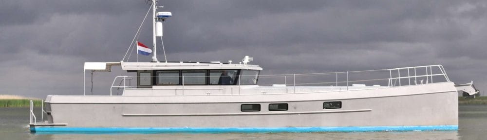
This is a list of the equipment we plan to have on board to support safe passagemaking, reliable communications whereever we are and the ability to share operational datalogging with our followers.
(needs some corrections/updates)
1. VHF & HF Communications
Icom IC-M605 Fixed VHF with Integrated AIS
The M605 is a fixed-mount DSC/AIS-capable VHF that does double duty: it handles standard voice communications and simultaneously monitors AIS traffic, displaying nearby vessels directly on the radio’s screen and feeding that data to the navigation network. 11 For a singlehanded skipper, having AIS awareness at the communications station — without needing to look at the chart plotter — reduces the cognitive load during a watch. The built-in automatic antenna tuner ensures optimal transmission performance across VHF frequencies. This is the primary emergency and routine communications link with other vessels, coast guards, and maritime services, and its reliability is non-negotiable.
Icom IC-M423GE handheld VHF with GPS (Backup)
No fixed VHF installation is complete without a handheld backup, and the M423GE adds integrated GPS. In a singlehanded scenario, if power is lost, the skipper falls overboard, or the primary radio fails, the handheld immediately provides position information alongside voice communication. For a boat pushing into high latitudes or remote waters, the M423GE means communication and self-rescue capability goes wherever the sailor goes — including into the dinghy or into the water.
Icom IC-M803 MF/HF SSB radio with Pactor modem
The IC-M803 is a modern MF/HF SSB transceiver certified to Class E DSC with 150 watts of output, delivering long-range voice communication well beyond the VHF horizon. Paired with a Pactor 4 modem, it becomes the backbone of an independent, subscription-light communications system: the crew can send and receive email via SailMail, download GRIB weather files, and pull weatherfax — all without relying on satellite connectivity. HF radio works from the poles to the tropics and is fully independent of commercial satellite infrastructure — critical redundancy on a vessel that may be weeks from the nearest port. The M803 also incorporates GPS input for DSC distress broadcasts and features audio replay, so the singlehander can review weather nets missed while resting.
2. AIS
Furuno FA-170 Class A AIS Transponder
The FA-170 is commercial/professional-grade Class A AIS — the same class mandatory on all SOLAS vessels. 19 Unlike the Class B units typically found on recreational yachts, Class A transmits at 12.5 watts (vs. 2 watts for Class B) and broadcasts position updates every 2 seconds when underway — meaning commercial ships, tankers, and coast guard stations see the LRC 58 exactly as they would see one of their own peers. The FA-170 is compliant with Bridge Alert Management (BAM) standards and provides a LAN interface that feeds AIS target data directly into the radar and chart plotters. In shipping lanes, restricted visibility, or congested harbors at high latitudes, being “Class A visible” to every bridge team in the area is a significant safety upgrade. The ability to send and receive safety-related messages to specific MMSIs adds a professional-level communications dimension rarely found on recreational vessels.
3. Autopilot
Furuno NavPilot 1000
The NavPilot 1000 is Furuno’s professional-grade Heading Control System (HCS), type-approved for vessels up to 100 meters LOA and certified for both IMO and non-IMO installations. 17 For a singlehanded ocean passage, the autopilot is not a convenience item — it is the most critical crew member on board. The NavPilot 1000 features an Auto Tuning function that automatically adjusts rudder gain, counter rudder, and rate of turn to match the vessel’s real-time behavior, meaning it continuously optimizes steering for sea state and load conditions without manual intervention. 5 Up to six “Work Profiles” can store pre-tuned parameters for different conditions — calm downwind running, a hard beat in a heavy sea, or harbor maneuvering — and the system connects to both analog and solenoid steering systems. The smooth TURN Mode ensures confident course changes. For long crossings where the skipper must rest, eat, and manage all other systems, a pilot of this caliber — designed for ships, deployed on a yacht — provides a qualitatively higher level of reliability than recreational-grade units.
4. Radar systems
Furuno DRS25A-NXT Solid-State Doppler Radar (Primary, 6 ft. antenna)
The DRS25A-NXT is the flagship of Furuno’s NXT series — a 200-watt solid-state radar using pulse compression and Doppler technology that sets a new standard for yacht-mounted radar performance. 16 Critically for watch-standing, Target Analyzer™ uses Doppler to automatically color-code targets that are approaching your vessel — green for separating, red for closing — giving the tired or solo sailor instant threat prioritization without poring over a cluttered screen. 13 Fast Target Tracking™ and Auto Target Acquire within 3NM automatically acquire potentially hazardous targets and trigger an alarm — the automated watchman the singlehander needs. Being solid-state means no magnetron to warm up: the radar provides full sensitivity from the instant it is switched on, which matters in the sudden squalls and fog common at high latitudes. Rain Mode renders rain cells in blue, allowing the operator to see through storm cells to the targets within. Bird Mode — while designed to locate fish — also helps identify concentrations of seabirds feeding on the surface, which can indicate whale activity below. The 6-foot antenna provides the narrow beam width and angular resolution needed to resolve targets in congested waters. 2
Furuno S-band radar
It will serve as a secondary radar head, allowing the NavNet network to run dual-radar configurations simultaneously. One antenna can be optimized for short-range/close-quarters work (e.g., harbor approaches, ice navigation) while the primary 25kW unit handles long-range detection. Having two independent radar sensors is proven redundancy at sea — if one unit develops a fault mid-ocean or mid-polar passage, navigation does not stop.
5. Night vison & collision avoidance
SEA.ai Watchkeeper (1280×512)
This is perhaps the most forward-thinking investment in the entire suite. The Watchkeeper system grew directly from the Oscar collision-avoidance system first developed in 2018 specifically for singlehanded sailors. It combines 4K low-light daylight cameras with long-wave infrared thermal imaging and an AI engine trained on millions of annotated marine objects — detecting floating debris, unlit vessels, buoys, marine mammals, and people in the water: precisely the category of hazards that AIS cannot see and radar frequently misses. For a vessel sailing singlehanded across an ocean — where rest periods are mandatory and a sleeping skipper cannot maintain a visual watch — the Watchkeeper provides the autonomous visual watchkeeping layer that no other instrument offers. It won the Innovation Route Award at the 2025 Cannes Yachting Festival in the category of “Solutions that improve the navigation experience,” recognized from over 120 entries. The thermal imaging performance in fog, rain, and darkness — conditions ubiquitous at high latitudes — makes it an essential layer of situational awareness that complements but does not duplicate radar or AIS.
6. Forward-looking sonar
Echopilot FLS-3D
Conventional echo sounders look straight down — they tell you how deep the water is under the keel right now. The Echopilot FLS-3D looks ahead, scanning the seabed in a 60° horizontal by 90° vertical arc with a forward range of up to 200 meters and depth detection to 100 meters. It delivers a real-time 3D visualization of the seabed terrain ahead, updating approximately once per second, and integrates directly into the NavNet MFD for simultaneous split-screen display alongside the chart. For entering atolls and lagoons — where charted depths are notoriously unreliable, particularly in the Pacific — this sonar provides the actual ground truth in real time that no chart can. It is equally valuable when navigating in poorly charted high-latitude waters, where sounding data may be decades old and ice scour may have reshaped the bottom. At up to 20 knots, it provides adequate reaction time for course corrections. This is the instrument that can prevent a catastrophic grounding in a remote location where rescue is measured in days.
7. Satellite communication & connectivity
Starlink Maritime + Pepwave Router
Starlink’s low-earth orbit (LEO) constellation delivers broadband speeds for weather routing, passage planning, crew communications, chart updates, and remote monitoring when within coverage. The Pepwave router provides multi-WAN management, bonding Starlink with other data sources for seamless failover.
Iridium Certus (polar backup)
Where Starlink coverage ends — or when geopolitical or atmospheric conditions interfere — Iridium Certus takes over. Iridium operates 66 LEO satellites in cross-linked polar orbits, giving it the only truly pole-to-pole satellite data network on Earth. Uniquely, Iridium’s satellite geometry means its signal quality improves at higher latitudes, as more satellites converge at the poles — precisely the opposite of geostationary systems that degrade or lose coverage above 75°N/S. 4 The Iridium Certus 700 service (via the Intellian C700 terminal) delivers up to 704 Kbps downlink and 352 Kbps uplink — sufficient for GRIB downloads, email, and GMDSS safety services. Polar regions are exclusively covered by the Iridium network; no other commercial satellite service reaches there. 12
Iridium GO (handheld backup) – discontinued – list replacement
A personal, handheld satellite communicator providing a last-resort voice and text connection anywhere on earth — another layer of redundancy that weighs almost nothing.
8. Emergency Equipment
Ocean Signal rescueME EPIRB1 Pro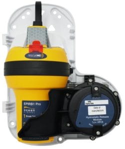
The LRC58’s design philosophy — long range, small crew, self-sufficiency at sea — makes a Cat I float-free EPIRB non-negotiable. The Ocean Signal rescueME EPIRB1 Pro delivers the full safety stack (satellite alert, GPS position, homing signal, visual strobe) in the most compact package on the market, with no recurring costs and a 10-year battery life that matches the long-term cruising mindset of an LRC58 owner.
Ocean Signal PLB3 (Personal Locator Beacon) for crew and guests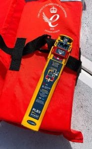
The Ocean Signal PLB3 represents a genuine step-change in personal distress beacon technology: it is the world’s first PLB to combine a 406 MHz Cospas-Sarsat signal with a simultaneous AIS distress broadcast. The 406 MHz MEOSAR signal alerts global rescue coordination centers within minutes. The simultaneous AIS signal means every vessel within VHF range — including the very ship that might effect a rescue — sees the distress position on their own AIS/chart plotter display, dramatically accelerating local response. 3 Return Link Service (RLS) sends a confirmation signal back to the beacon confirming transmission — giving the person in the water the assurance that rescue services have been alerted. GNSS via both GPS and Galileo provides precise positioning, and both visible and infrared strobes assist search teams arriving on scene. For a singlehanded passage where a man-overboard event would otherwise be unsurvivable, this beacon is life insurance worn on the body.
9. Weather station
Airmar 300WX (Heated — 300WXH)
The Airmar 300WX is the de facto standard weather station for serious offshore and professional marine applications. It is a self-contained ultrasonic instrument — no moving parts, nothing to foul or break — that provides wind speed and direction, barometric pressure, air temperature, humidity, dew point, heat index, wind chill, and GPS positioning in a single sealed unit. By combining ultrasonic wind sensing with GNSS and motion sensors, the 300WX calculates dynamic true wind while the vessel is underway — accounting for the vessel’s own speed and heading — which is the data actually needed for sail trim and weather assessment. The heated model (300WXH) is Airmar’s specifically recommended instrument for ice-prone areas: an integrated heater keeps the ultrasonic wind channel free of ice and frost, ensuring accurate wind data is maintained when sailing at high latitudes where icing conditions are common. 1
10. Compass & heading
Furuno SC-130 Satellite Compass
Traditional fluxgate compasses are affected by magnetic deviation from onboard electronics, rigging, and the vessel’s own magnetic signature — errors that must be constantly corrected and recalibrated. The SC-130 is a GNSS-based tri-antenna satellite compass with a heading accuracy of 0.25° rms — far superior to any magnetic compass and unaffected by onboard magnetic fields. 8 Critically, GNSS compasses do not suffer from the polar magnetic anomalies that make magnetic compasses unreliable at high latitudes, where the horizontal component of Earth’s magnetic field becomes weak and erratic. The SC-130 settles in approximately 90 seconds and continuously provides heading, position, SOG, COG, rate of turn, and 3-axis speed data to feed the autopilot, radar, AIS, and chart plotters. 7 This single unit improves the accuracy and reliability of every other navigation system it feeds.
11. Depth & Sonar
Furuno DFF1-UHD TruEcho CHIRP Network Sounder
The DFF1-UHD is Furuno’s professional-grade network depth sounder, using TruEcho CHIRP technology that sweeps across 90 frequencies simultaneously (30–70 kHz and 175–225 kHz). 15 The result is up to 5× greater target resolution than a conventional fixed-frequency sounder, with 1 kW of output power delivering 1,000 times more acoustic energy into the water. This enables sharp, detailed bottom structure imaging — important both for avoiding grounding on uncharted bottom features and for understanding the seabed when anchoring in remote locations. The sounder integrates directly into the NavNet TZtouch3 network, displaying depth on any MFD alongside charts. Combined with the Echopilot FLS-3D forward sonar, the LRC 58 has a complete 360° sonar picture: forward awareness plus real-time depth underfoot.
12. Displays
Furuno NavNet TZtouch3 — 2× TZT19F (19″ MFDs)
Two 19-inch full-HD (1920×1080) IPS all-glass displays form the heart of the navigation station. The TZtouch3 platform features a quad-core processor for instant response, multi-touch gesture control combined with physical hybrid controls (knobs and buttons for gloved hands or rough conditions), and seamless integration of every sensor in the Furuno ecosystem: radar, AIS, sounder, sonar, compass, weather station, and chart data. 6 Having two independent 19″ screens creates a genuine glass bridge: one screen can be dedicated to radar/AIS overlay while the other runs charts and sonar in split-screen. The system is scalable — sensors can be added, swapped, or reconfigured via software as the vessel’s needs evolve. 10 The PIN Code Lock feature protects the configuration from accidental alteration. For a singlehanded passage, the ability to absorb maximum situational awareness from two large, bright, information-dense screens at a glance — without hunting through menus — is a genuine safety multiplier.
13. Navigation software
PredictWind
PredictWind was developed for ocean racing (including America’s Cup campaigns) and runs proprietary high-resolution weather models alongside ECMWF and GFS data.Its Offshore App is specifically designed to download GRIB weather data over SSB radio or satellite connections, minimizing data usage while delivering the forecasts needed offshore. 9 Weather routing calculates optimal routes factoring in tides, currents, wind, waves, depth contours, and the vessel’s own polar performance data — the tool that turns a forecast into a concrete departure decision and passage plan. Ensemble forecasts extend 28 days, essential for planning long transoceanic crossings around weather windows.
TimeZero Professional (TZ Professional / coastal explorer)
TimeZero is Furuno’s licensed charting partner and provides the desktop-grade navigation software that complements the TZtouch3 MFD ecosystem. Running on the fanless Windows PC, TZ Professional brings full ECDIS-class chart management, passage planning, and route monitoring to a large 16″–19″ touchscreen at the navigation table. It connects natively to the Furuno NavNet network, sharing data bidirectionally with the helm MFDs so routes and targets are always in sync. The PC-based platform is also the integration point for Signal K data feeds, weather overlay, and custom displays.
14. Automation Platform: Signal K + Node-RED
Signal K is the open-standard marine data platform that aggregates data from every NMEA 0183 and NMEA 2000 device on board into a unified, structured data stream — accessible to any networked device (tablet, phone, custom display, or automation engine). 14
Node-RED is a visual flow-based programming environment that connects to Signal K and enables custom automations without requiring deep coding expertise. 18 For the LRC 58, this platform enables:
- Automated watch alarms — waking the singlehanded skipper on a programmable schedule, or when a target enters a defined CPA (closest point of approach) threshold
- Bilge and tank monitoring — alerts for abnormal bilge pump cycles or fuel/water levels without manual inspection
- Engine health logging — continuous recording of RPM, temperatures, pressures, hours, and alarms into a searchable time-series database
- Custom dashboards — sending any combination of boat data to tablets, phones, or the PC touchscreen in any format desired, including “glass bridge” lighting, tank levels, and ambient environmental data
- Automated weather logging — recording Airmar 300WX data at regular intervals to build a passage weather history
The combination of Signal K + Node-RED running on a NUC (small industrial PC) gives the LRC 58 a level of data integration, automation, and logging previously available only on commercial vessels with dedicated systems engineers — all on open-source, community-supported software that can be extended and modified at any time.
Summary
| Category | Equipment | Key Benefit for LRC 58 |
|---|---|---|
| VHF Primary | Icom M605 + AIS | Integrated AIS awareness at comms station |
| VHF Backup | Icom M423GE | Handheld GPS VHF goes everywhere, including overboard |
| HF/SSB | Icom M803 + Pactor | Independent long-range comms & weather; works globally without subscription |
| AIS | Furuno FA-170 Class A | Professional visibility to all commercial traffic; 12.5W, 2-sec updates |
| Autopilot | Furuno NavPilot 1000 | Ship-grade pilot for singlehanded passages; auto-adaptive, 6 profiles |
| Radar (main) | Furuno DRS25A-NXT 6ft | 200W solid-state Doppler; instant-on, Target Analyzer™, rain/bird mode |
| Radar (secondary) | Furuno DRS6A-NXT | Redundancy; dual-radar short/long range simultaneously |
| AI Watch | SEA.ai Watchkeeper | 24h autonomous visual watch; thermal + AI; detects what radar/AIS miss |
| Forward Sonar | Echopilot FLS-3D | 200m forward seabed imaging; essential for atolls & uncharted water |
| Satellite (main) | Starlink Maritime | Broadband where available; weather, planning, crew comms |
| Satellite (polar) | Iridium Certus | Only pole-to-pole coverage; improves at high latitudes |
| Emergency beacon | Ocean Signal PLB3 | 406MHz + AIS dual-alert; RLS confirmation; GPS + Galileo; no subscription |
| Weather station | Airmar 300WXH | Heated ultrasonic; no moving parts; dynamic true wind; polar-ready |
| Compass | Furuno SC-130 | 0.25° satellite compass; immune to magnetic anomalies at high latitude |
| Depth sounder | Furuno DFF1-UHD | CHIRP across 90 frequencies; 5× resolution; 1kW; feeds whole NavNet |
| MFD Displays | 2× Furuno TZT19F 19″ | Full-HD IPS glass bridge; quad-core; hybrid touch/physical controls |
| Weather routing | PredictWind | Racing-proven models; GRIB via SSB/satellite; 28-day ensemble routing |
| Chart software | TZ Professional | ECDIS-class planning; native Furuno NavNet integration |
| Automation | Signal K + Node-RED | Open platform; watch alarms, engine logging, custom displays, alerting |
This equipment suite reflects what I think is a coherent philosophy: professional-grade hardware where it matters most (AIS, autopilot, radar, compass), layered redundancy across communications and navigation (VHF/SSB/Starlink/Iridium), genuine innovations that close the gap on singlehanded watchkeeping (SEA.ai, NavPilot 1000, Signal K automations), and specialized instruments for the specific challenges of high-latitude and atoll sailing (Iridium Certus, 300WXH, Echopilot FLS-3D, SC-130 satellite compass).
Why settle for less when your life may depend on it?